In today's rapidly advancing technological landscape, the integration of sophisticated geo techniques and game theory principles could and hopefully will transform our industry and move the needle in damage prevention. This article delves into the synergy between these concepts, exploring how super-resolution satellite imagery, enhanced through Generative Adversarial Networks (GANs), is revolutionizing our ability to audit, monitor, and improve safety measures. By leveraging these innovative approaches, organizations can proactively address risks, ensuring a safer and more resilient environment.
The Role of Game Theory in Super-Resolution
Game theory, a fundamental concept in economics, provides a powerful framework for understanding strategic interactions between competing entities. This theory is particularly relevant in the context of Generative Adversarial Networks (GANs), which are employed to enhance the resolution of satellite images—a process known as super-resolution.
GANs are the tech behind deep fakes which I'm sure most of us are familiar with and probably kind of scared of. It's hard to know what's real and what's not. Thankfully in damage prevention we have a positive use for this technology. GANs consist of two neural networks: the generator and the discriminator. The generator's task is to create high-resolution images from low-resolution inputs, while the discriminator evaluates the authenticity of these generated images. The generator aims to "fool" the discriminator into believing that the generated images are real, thereby improving the quality of the images through continuous feedback. This dynamic mirrors a zero-sum game in game theory, where one player's gain is another's loss.
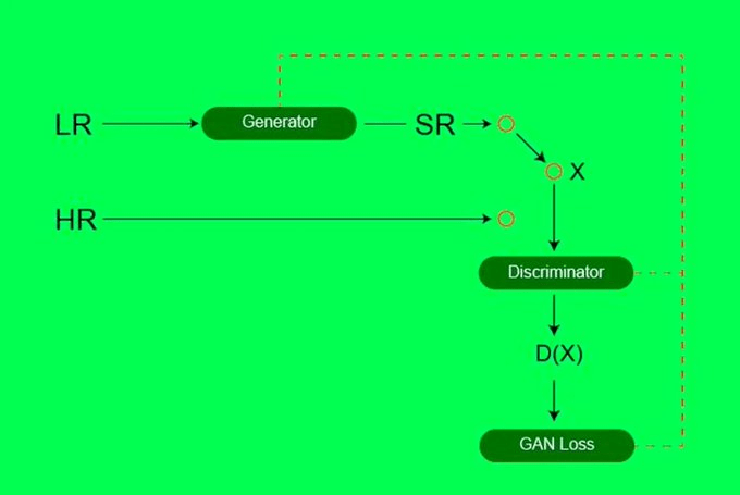
The ultimate goal of GANs is to reach a Nash Equilibrium, where the generator produces images so realistic that the discriminator cannot distinguish them from genuine high-resolution images. At this point, both networks are performing optimally, with neither able to improve their strategies further. This competitive interplay drives the continuous enhancement of image resolution, resulting in highly detailed satellite imagery.
Deep Faking Satellite Imagery with GANs
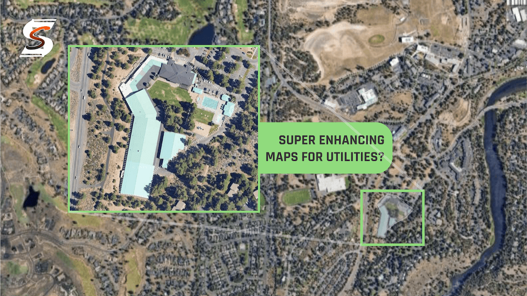
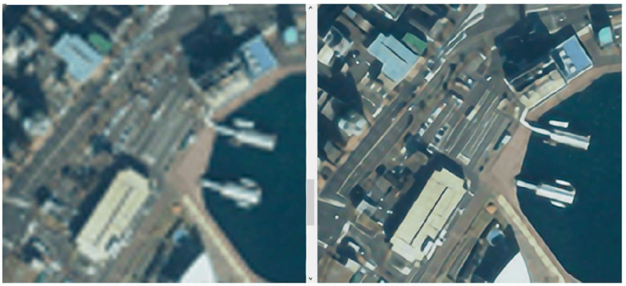
The process of super-resolution using GANs involves transforming low-resolution satellite images into high-resolution ones, providing a detailed view of the Earth's surface. This technology is crucial for damage prevention, as it allows for precise monitoring of infrastructure, natural landscapes, and urban environments.
GANs, by leveraging deep learning models, enhance the resolution of images from satellites like Sentinel-2, which typically offer resolutions of 10 meters. Through super-resolution techniques, these images can be refined to resolutions as fine as 2.5 meters or even 1 meter. This level of detail is invaluable for identifying potential hazards and vulnerabilities that may not be visible in lower-resolution images.
3 Practical Applications in Damage Prevention
1. Infrastructure Monitoring and Maintenance
High-resolution satellite images could enable detailed inspection of critical infrastructure such as bridges, roads, and pipelines. By identifying structural anomalies, cracks, and other signs of wear and tear, maintenance efforts can be prioritized and scheduled proactively, preventing catastrophic failures. Not everything is able to be captured by a drone because drones aren't allowed in a lot of areas, so this is a good alternative.
2. Environmental and Natural Disaster Management
Enhanced imagery could aid in the early detection of environmental changes and natural hazards. For instance, monitoring coastal erosion, deforestation, and riverbank shifts can help mitigate the impacts of floods, landslides, and other natural disasters. Accurate and timely data allows for the implementation of preventive measures, safeguarding communities and ecosystems. Proactive damage prevention is often the best kind and has the most ROI.
3. Urban Planning and Development
In urban areas, high-resolution images provide detailed insights into land use, construction activities, and population density. This information is vital for effective urban planning, ensuring that infrastructure development aligns with safety standards and minimizes risks associated with overcrowding and improper land use.
The Importance of Regular Audits and Data Improvement
To maximize the benefits of super-resolution and GAN-enhanced imagery, regular audits of existing data are essential. Audits ensure that the data used for analysis and decision-making is accurate, up-to-date, and reflective of current conditions. This is particularly important when dealing with older data sets, which may still hold valuable information but require validation and refinement to maintain their relevance.
Conducting regular audits helps verify the accuracy of existing data, identifying discrepancies and outdated information. By cross-referencing satellite images with ground-truth data, organizations can ensure that their analyses are based on reliable information, enhancing the credibility of their findings.
As technology advances, the ability to enhance older data sets with new techniques like GANs becomes increasingly feasible. By applying super-resolution methods to historical satellite images, organizations can extract more detailed information from previously low-resolution data, providing a richer context for ongoing monitoring and analysis.
The dynamic nature of GANs, driven by game theory principles, ensures continuous improvement in image resolution and accuracy. This adaptability is crucial for damage prevention, as it allows for the ongoing refinement of monitoring techniques and the development of more effective preventive measures.
Conclusion: A Collaborative Approach to Safety
The integration of geo techniques and game theory in damage prevention exemplifies the potential of interdisciplinary approaches to address complex challenges. By leveraging advanced technologies like GANs for super-resolution, organizations can significantly enhance their ability to monitor and mitigate risks, ensuring the safety and resilience of both built and natural environments.
As we move forward, it is imperative to foster collaboration between technology experts, policymakers, and industry leaders. Together, we can harness the power of these innovative techniques to create a safer, more secure world, where proactive damage prevention is the norm rather than the exception.
Through continuous learning, adaptation, and the application of cutting-edge technologies, we can lead the way in safeguarding our infrastructure, communities, and ecosystems from potential harm. The journey toward enhanced damage prevention is a collective effort, and by embracing these advancements, we can achieve a safer and more sustainable future for all.

Interested in learning more? I'd recommend this article: https://yohaniddawela.substack.com/p/how-accurate-are-super-resolution

RECENT POSTS


LATEST FROM NO DAMAGE
Share this Post